Ngauranga is a suburb of New Zealand's capital city, Wellington, in the lower North Island. Situated on the western bank of Wellington Harbour, it lies to the north of the centre of the city.
Ngauranga is lightly populated, and for statistical purposes is divided into Ngauranga East and Ngauranga West by Statistics New Zealand. At the 2001 New Zealand census, Ngauranga West registered a population of zero, while Ngauranga East had a population of 39. This represented an increase of 18.2% or 6 people since the previous census in 1996.
The low population is due to Ngauranga's rugged terrain. It includes the Ngauranga Gorge, through which State Highway 1 passes on its route out of Wellington to Porirua and the west coast. To the east, State Highway 2 runs wedged between hills and Wellington Harbour on its route from Wellington to the Hutt Valley, Wairarapa, and beyond.
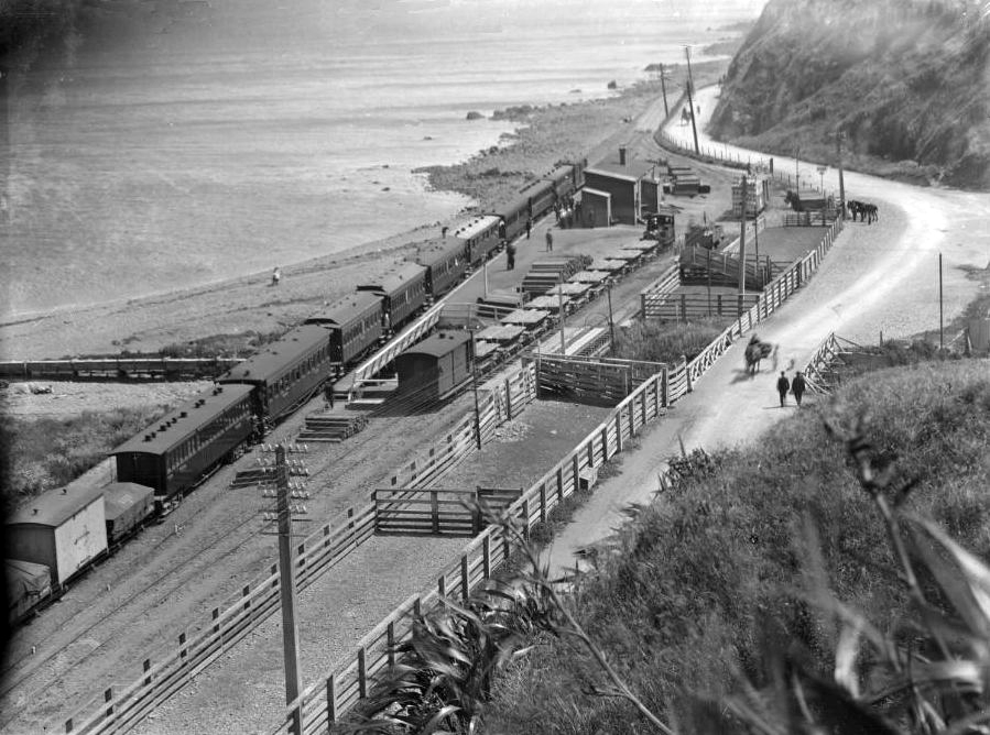
Alongside State Highway 2 is the Hutt Valley Line portion of the Wairarapa Line railway, which includes a station in Ngauranga served by frequent commuter trains. The North Island Main Trunk railway also passes through Ngauranga, via two tunnels of the Tawa Flat deviation, with a bridge between them crossing the Ngauranga Gorge.
The small amount of usable land in Ngauranga is primarily used for commercial and industrial activity, though there are some houses on the hill overlooking the motorway.
Etymology
The name comes from the Māori language ngā ūranga, meaning "the landing place (for canoes)". Ngauranga Railway Station was known as "Ngahauranga" when it opened in 1874. A 1901 article in Māori stated that Ngahauranga was incorrect, but in 1946 Member of Parliament Eruera Tirikatene stated that Ngahauranga was correct and meant "beaten by strong winds". Both spellings, Ngahauranga and Ngauranga, were used in the press as late as the 1970s.
Geography
The suburb of Ngauranga consists of hilly terrain bisected by the Ngauranga Gorge. Along the harbour's edge are steep bluffs. The landscape of Ngauranga has been radically altered by quarrying and leveling of the hills to provide areas for industry and for motorway development.
The Waitohi Stream (also known as Ngauranga Stream) used to flow down the gorge, forming a long lagoon at the base of the hills near the sea. Coutts Crawford described the gorge as he had seen it in 1839: "This valley, or gorge, was then extremely pretty. There was a pa with some cultivations cut out of the bush, but beyond that was the virgin forest. The stream was then unpolluted by masses of shingle, and flowed steadily". The stream was culverted and the lagoon disappeared as the road through the gorge was built and industries were established, and by September 1939 the stream was completely piped as far as the harbour.
Tyer's Stream rises from the hills of Khandallah on the south-western side of the gorge and flows down to meet the former Waitohi Stream.
History
Māori settlement
There was a Māori settlement at the base of the Ngauranga Gorge in the nineteenth century. In 1835 the Ngāti Mutunga people who had been living there departed for the Chatham Islands, and chief Te Wharepouri and others moved in to the area, clearing bush and building two European-style houses at Ngauranga. Te Wharepouri sold land around Wellington, including Ngauranga, to the New Zealand Company when the Tory arrived at Wellington in 1839. In 1847 the New Zealand Company reserved several sections of land at Ngauranga for Māori. When Te Wharepouri died in 1842, he was buried at Petone and a canoe was later placed upright in the ground at Ngauranga as a memorial.
In 1850, a government report stated that there were 34 inhabitants at Ngauranga, who were followers of the late Te Wharepouri. They had gardens nearby and also reared poultry which they sold along with firewood and fish. The same report stated that E Tako and his followers were intending to move from Kumototo in Wellington to Ngauranga. By 1862 only five Ngāti Tāwhirikura people were living at Ngauranga, with many of the tribe having gone to New Plymouth.
The reserve lands at Ngauranga went through the Native Land Court in 1886. From this time, Māori reserve land at Ngauranga was lost through succession, partition and land sales. Some was also lost to the Government, who took land for defence, road and rail during the 1880s.
European activity
Possibly the first European to live at Ngauranga was a Mr Smith, who Coutts Crawford met in 1839 at his home close to the Ngauranga Stream. Smith told Crawford that Colonel Wakefield of the New Zealand Company had bought the land and left him in charge.
Before a bridge was built across the Ngauranga Stream in 1856 to facilitate movement between the Hutt Valley and Wellington, Māori would transport people across the stream by canoe or by carrying them on their backs.
A road through Ngauranga Gorge, now part of State Highway 1, was opened in 1858 to provide access from Wellington to Porirua and the Kāpiti Coast. It has been upgraded many times.
In the early days, Ngauranga was a busy coach stop on the road to Wellington from the Hutt Valley and Porirua. Sometimes vehicles would have to halt there if the roads were flooded or blocked by slips. W E Wallace established a hotel at Ngauranga in 1864, and Thomas Clapham's 'Ngahauranga Inn' was built soon after. Wallace's Inn was sold to James Futter in 1866 and later became the White Horse Hotel. Refurbished and then rebuilt, the White Horse Hotel operated as a hotel until 1908 when the district went 'dry', and after that was run as a boarding house. It was destroyed by fire in July 1914.
Nineteenth century industries in the area included a flour mill with water wheel operating throughout the 1850s, and a number of abattoirs and associated animal-processing businesses such as fellmongers, wool scourers, tanneries, and a manure and glue works. In the 21st century, a variety of businesses are located around Ngauranga Gorge.
Abattoirs
A number of abattoirs have operated at Ngauranga. James and Henry Barber built a slaughterhouse at Ngauranga around 1865 after being denied a licence to continue slaughtering animals within the city limits. In 1883 their business was taken over and the Wellington Meat Preserving and Refrigerating Company was formed. Also in 1883, the Wellington Meat Export Company established an abattoir and marshalling yards at Ngauranga. In 1887, the Wellington Meat Preserving and Refrigerating Company opened a large new abattoir designed by Thomas Turnbull. The company also built a railway siding about 400 m long to transfer processed meat to the railway at Ngauranga Station. Wellington Meat Export Company and Wellington Meat Preserving and Refrigerating Company merged in 1889, and the business operated until 1973. It closed because the company could not economically upgrade the works to meet new standards in hygiene and pollution control. These early abattoirs discharged effluent including blood and solid organic matter into the Ngauranga Stream before and after the stream was piped. Until the practice stopped, cloudy red water could often be seen in the harbour alongside Ngauranga. Giant petrels used to be quite common in Wellington Harbour around Ngauranga, feeding on offal from the abattoirs discharged into the harbour.
Wellington City Council erected a municipal abattoir at Ngauranga in 1909, levelling land and enclosing part of Ngauranga Stream as part of the works. The municipal abattoir was expanded in the late 1980s to process meat for export, then sold to Taylor Preston in 1991, with the council retaining a 51% share at that time. As of 2025, Taylor Preston still operates a meat-processing facility in Ngauranga Gorge.
Fort Kelburne
Fort Kelburne was a coastal artillery battery built between 1885 and 1887 at Ngauranga due to fears of possible war with Russia, the so-called 'Russian Scare'. Fort Kelburne and Fort Buckley at Kaiwharawhara were the first coastal defences to be built in a ring that was designed to protect Wellington Harbour. The fort was used for training purposes and was renovated during the First World War. After the war, ownership transferred to the Public Works Department. In 1963, the fort was demolished by the Public Works Department to make way for two large connecting roads between the Wellington Urban Motorway and Ngauranga Gorge.
Transport
Ngauranga has the southern junction of SH1 and SH2.
Ngauranga is also served by rail. Ngauranga has one railway station, Ngauranga Railway Station. Bus services between Wellington and the Hutt Valley, and Wellington and Johnsonville/Newlands, pass through Ngauranga.
See also
- Ngauranga Gorge
References
External links
- "Official opening of highway up gorge, 1939 (photo)". Evening Post in Papers Past. 1939.